Interesting Civil War Railroad Detail at City Point

My model railroad page now has a bit of information about the use of super-elevated track during the Civil War. Check it out at http://www.willegal.net/railroad/citypoint/cprailroad.htm

I recently made contact with a potentially great source of information on the City Point and Army Line Railroad. The information he says he has, would greatly expand my knowledge and I would definitely share it on my website. Whether this person can find the time to help me, will be determined, but if he does comes through, it has the potential to be quite awesome.

Visit to Kennesaw Mountain

The day after VCF east, I visited a couple of Civil War sites north of Atlanta. I already reported on my visit to Allatoona Pass.

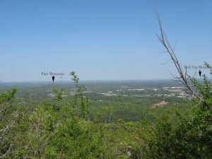
After hiking around Allatoona, I drove south to Kennesaw and did the hike to the top of Kennesaw Mountain, which took about an hour. Kennesaw Mountain rises about 800 feet above the surrounding countryside. The view from the top is impressive. You can see from Atlanta in the south to Allatoona in the North, a span of something like 50 miles. Except for a few isloated Mountains, the country is of a gently rolling nature, much like eastern Massachusetts. It is no wonder that the few mountains played such a key role in the Civil War Campaign for Atlanta. The holders of those hills, had huge advantages of observation and communication. Here is a picture I took from the top of Kennesaw, looking north.

Looking north from Kennesaw

Looking north from Kennesaw

The other thing I noticed while hiking Kennesaw is that the main Confederate trench lines were located near the top. Certainly part of the reason for this is that the energy of any attackers would be reduced by the climb up to reach them. Certainly, making a successful attack against this position would have been very difficult. However another the thing to keep in mind is that the mountain is only about a mile long, part of a six mile long defensive line. Eventually Sherman was able to flank this line, like the ones before it.

Battlefield at Allatoona Pass, Georga

The day after Vintage Computer Festival Southeast, I spent some time north of Atlanta visiting some Battlefields. First I visited the Battlefield at Allatoona Pass. For numbers engaged, this is said to be the bloodiest battle of the Civil War. You can read a bit about the battle here.

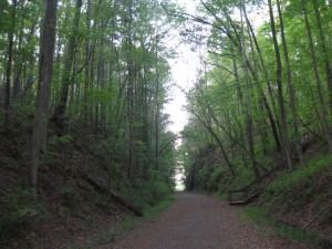
The battlefield is now a very peaceful State Park. It is located about 20 miles north of Kennesaw about a mile or so off of I-75. Here is an image of the pass looking from North to South.

Allatoona Pass

Allatoona Pass

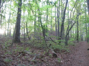
The next picture shows the initial position of the 12th Illinois, looking from the Confederate approaches. This position is a natural bastion and seems like it would be very difficult to attack. Indeed the attacks upon this position failed early on and were not pressed. The 12th Illinois later vacated this position and went to a more threatened position.

Position of 19th Indiana (at top of bluff)

Position of 19th Indiana (at top of bluff)

The most interesting thing I found about this battlefield is the state of preservation of the earthworks, most of which are extraordinary. I was a bit confused as to why the remaining defenses are mostly oriented to face an attack from the north. This is despite that fact that the Confederates surrounded this position and attacked from all sides. History say that there were south facing defenses, but none remain.

Later in day, I asked the ranger at Kennesaw Headquarters about this, and he thought for a minute and said that the reason is that these defenses were taken over from the Confederates, who had erected defenses here to stop Sherman from reaching Atlanta. However this doesn’t completely explain why the records indicate that there were south facing fortifications, that are now, nowhere to be seen. This is in direct contrast to the extraordinary condition of the north facing defenses.

I have been thinking about it off and on for a few weeks and have a possible explanation. The north facing defenses were probably constructed by the Confederates (probably slaves) and reused by the US troops. However, the US troops had to construct their own south facing defenses. Due to lack of time, energy and the likelihood that this position was only likely to be attacked by raiders, they constructed log breastworks from felled trees, instead of digging proper entrenchments. Those south facing wood breastworks constructed by US troops either rotted away or were burned as firewood by neighboring families and now leave little trace. Now this is pure conjecture, but it is the only way that I can rectify the historical record of an all around defense with remaining evidence.

There is one other thing that bothered me, when walking the ground. The trenches of the 4th Minnesota end at the sunken wagon road that passes across the hill. Between the 4th Minnesota and the 12th Illinois, was a gully that some Confederates used for cover when their attack failed. These Confederates were trapped in this gully and some 80 of them ended up surrendering at the close of the battle. However the trenches of the 4th Minnesota do not face this gully and the 12th Illinois left their positions to reinforce other positions after the Confederate attacks on them failed. So how did the 4th Minnesota maintain enough firepower to keep these Confederates pinned down in a gully that their trenches did not face. My conclusion, is that the left of the 4th Minnesota had to be refused and extended along the sunken wagon road, which directly overlooked the gully containing the trapped Confederates. Today, this sunken road is the perfect depth to act as an entrenchment. Another piece of pure conjecture, but it is the only possible explanation that makes sense to me.

Stay tuned, I’ll talk a bit about Kennesaw Mountain in a future post.

The “Harvest of Death” photo

Excuse the morbid curiosity exhibited in this post. I debated whether to post or not, and in the end, decided to do so.

Most days, I’ve taken the time to view the latest entry in the “Gettysburg Daily” blog. Recently Jerry Coates did a report on his assertion about where the “Harvest of Death” photos were taken, as William Frassanito could not find the location of these photo’s. I’m pretty well convinced by Jerry Coate’s argument, that the pictures are of the 5th New Jersey near the Spangler farm.

The image, can be found on the Library of Congress website. http://lcweb2.loc.gov/cgi-bin/query/r?ammem/cwar:@field(NUMBER+@band(ppmsc+00168))

I’ve always been struck by the fact that this photo seems to depict the dead as they fell in a line of battle, not as a row of dead lined up to be buried.
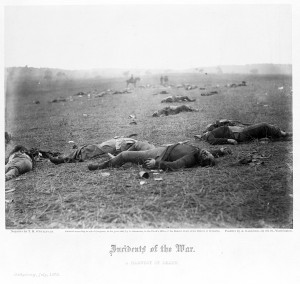
harvest of death

There is another article by Coates describing his line of thinking at: http://www.gdg.org/Gettysburg%20Magazine/coates.html

In that article, Jerry lists the name and companies of the 13 soldiers of the 5th New Jersey that were killed on the second day at Gettysburg. I’m reordering that list here by company.

Lt. Henry R. Clark, Company A
Pvt. Patrick Tynan, Company A
Pvt. Samuel W. Bradford, Company A
Cpl. Edgar S. Van Winkle, Company B
Pvt. Ananias Lynn, Company B
Pvt. John Ryan, Company C
Pvt. Heinrich Troch, Company E
First Sgt. Theodore Sutphin, Company F
Pvt. John 0. Heath, Company G
Pvt. John H. Johnson, Company H
Pvt. Samuel Hasselman, Company H
Lt. Thomas Kelly, Company I
Pvt. Edward Martin, Company I
Pvt. John Ensch, Company K

Regiments in the Civil War were deployed in lines with soldiers touching shoulders with each other. This is normally estimated as a spacing of about 28 inches frontage per soldier. The usual deployment of a regiment was 2 lines. In this battle, the 5th New Jersey deployed as a single line to cover all the ground they were assigned. Apparently the left end was turned back or in military parlance, refused. With 206 enlisted men and about 28 inches per soldier, they should have covered about 160 yards of frontage (28/36 x 206 = 160). That would be an average of 16 yards or 48 feet per company. The 10 companies of a regiment normally deployed with Company A on the right, proceeding to Company K on the left. There is no Company J in the 5th New Jersey. There is no evidence that the 5th New Jersey would have deviated from this standard deployment of companies at Gettysburg.

If we assume killed in action died close to where they were hit and have not been moved prior to the photo, there should be a distribution of bodies similar to this chart. Company A, being closer to the Camera, and Company K being in the distance.
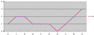
KIA per company

KIA per company

According to Coates theory, this “Harvest of Death” photo looks southward from near the Spangler farm, along the line of the 5th New Jersey.

So we are probably looking down the line of battle, starting at company A, then B and so on. Note how the distribution of bodies in the image is similar to the distribution of killed in the various companies. A bunch of bodies are near the camera, where companies A and B suffered the most KIA of the regiment. Then there is a relative lack of bodies where the center companies were in line. It is hard to make out the distant bodies clearly, but it is possible that there are more bodies there, than in the center of the line. Also, you can see the debris that shows where the left of the regiment was refused.

I do have a question though. It just doesn’t seem like the line extends for 160 yards in this image. Is this due to a telephoto type lens fore-shortening the image, or was the line of the 5th New Jersey shorter than simple math would expect? If the characteristics of O’Sullivans camera lens is investigated, maybe the answer could be provided.

If all the assumptions are correct, then the nearest bodies are those of company A, B and possibly C. If you use your imagination, no men are visible where company D was positioned and the single KIA of companies E, F and possibly G alone in the mid-distance. Could they be the bodies of Pvt. Heinrich Troch (company E), First Sgt. Theodore Sutphin (company F) and Pvt. John 0. Heath (company G)?

Since we know the dead in each of these companies, a person could try to find carte de visites of the slain soldiers of companies A, B and C, and possibly try to identify those bodies.

If all these assumptions are true, it also indicates that KIA in the Civil War, means just that. Soldiers killed in action would have died very close to where they were hit. Though the image is only sharp in the foreground, I can be reasonably sure that 8 bodies are in view. It appears that several more might be in the haze in the background, others buried already, and one unfortunate soldier might be barely showing on the left side of the image. It could be that almost all 14 of the KIA of the 5th New Jersey are in this photo. If any Confederates were killed in this area, they would have been buried before the photo was taken, while the Confederates still occupied this ground.

Also keep in mind that the 5th New Jersey suffered 60 wounded soldiers during the battle, most of whom were probably wounded at this location. It is sobering to to think of the horror that the men of this regiment experienced, during this engagement.