Interesting Civil War Railroad Detail at City Point

My model railroad page now has a bit of information about the use of super-elevated track during the Civil War. Check it out at http://www.willegal.net/railroad/citypoint/cprailroad.htm

I recently made contact with a potentially great source of information on the City Point and Army Line Railroad. The information he says he has, would greatly expand my knowledge and I would definitely share it on my website. Whether this person can find the time to help me, will be determined, but if he does comes through, it has the potential to be quite awesome.

Visit to Kennesaw Mountain

The day after VCF east, I visited a couple of Civil War sites north of Atlanta. I already reported on my visit to Allatoona Pass.

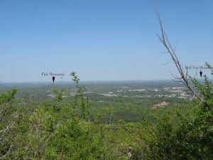
After hiking around Allatoona, I drove south to Kennesaw and did the hike to the top of Kennesaw Mountain, which took about an hour. Kennesaw Mountain rises about 800 feet above the surrounding countryside. The view from the top is impressive. You can see from Atlanta in the south to Allatoona in the North, a span of something like 50 miles. Except for a few isloated Mountains, the country is of a gently rolling nature, much like eastern Massachusetts. It is no wonder that the few mountains played such a key role in the Civil War Campaign for Atlanta. The holders of those hills, had huge advantages of observation and communication. Here is a picture I took from the top of Kennesaw, looking north.

Looking north from Kennesaw

Looking north from Kennesaw

The other thing I noticed while hiking Kennesaw is that the main Confederate trench lines were located near the top. Certainly part of the reason for this is that the energy of any attackers would be reduced by the climb up to reach them. Certainly, making a successful attack against this position would have been very difficult. However another the thing to keep in mind is that the mountain is only about a mile long, part of a six mile long defensive line. Eventually Sherman was able to flank this line, like the ones before it.

Battlefield at Allatoona Pass, Georga

The day after Vintage Computer Festival Southeast, I spent some time north of Atlanta visiting some Battlefields. First I visited the Battlefield at Allatoona Pass. For numbers engaged, this is said to be the bloodiest battle of the Civil War. You can read a bit about the battle here.

The battlefield is now a very peaceful State Park. It is located about 20 miles north of Kennesaw about a mile or so off of I-75. Here is an image of the pass looking from North to South.
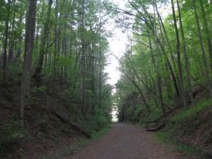
Allatoona Pass

Allatoona Pass

The next picture shows the initial position of the 12th Illinois, looking from the Confederate approaches. This position is a natural bastion and seems like it would be very difficult to attack. Indeed the attacks upon this position failed early on and were not pressed. The 12th Illinois later vacated this position and went to a more threatened position.
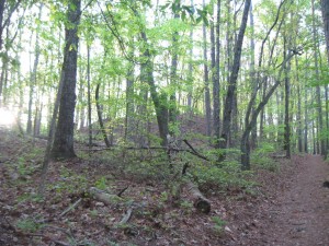
Position of 19th Indiana (at top of bluff)

Position of 19th Indiana (at top of bluff)

The most interesting thing I found about this battlefield is the state of preservation of the earthworks, most of which are extraordinary. I was a bit confused as to why the remaining defenses are mostly oriented to face an attack from the north. This is despite that fact that the Confederates surrounded this position and attacked from all sides. History say that there were south facing defenses, but none remain.

Later in day, I asked the ranger at Kennesaw Headquarters about this, and he thought for a minute and said that the reason is that these defenses were taken over from the Confederates, who had erected defenses here to stop Sherman from reaching Atlanta. However this doesn’t completely explain why the records indicate that there were south facing fortifications, that are now, nowhere to be seen. This is in direct contrast to the extraordinary condition of the north facing defenses.

I have been thinking about it off and on for a few weeks and have a possible explanation. The north facing defenses were probably constructed by the Confederates (probably slaves) and reused by the US troops. However, the US troops had to construct their own south facing defenses. Due to lack of time, energy and the likelihood that this position was only likely to be attacked by raiders, they constructed log breastworks from felled trees, instead of digging proper entrenchments. Those south facing wood breastworks constructed by US troops either rotted away or were burned as firewood by neighboring families and now leave little trace. Now this is pure conjecture, but it is the only way that I can rectify the historical record of an all around defense with remaining evidence.

There is one other thing that bothered me, when walking the ground. The trenches of the 4th Minnesota end at the sunken wagon road that passes across the hill. Between the 4th Minnesota and the 12th Illinois, was a gully that some Confederates used for cover when their attack failed. These Confederates were trapped in this gully and some 80 of them ended up surrendering at the close of the battle. However the trenches of the 4th Minnesota do not face this gully and the 12th Illinois left their positions to reinforce other positions after the Confederate attacks on them failed. So how did the 4th Minnesota maintain enough firepower to keep these Confederates pinned down in a gully that their trenches did not face. My conclusion, is that the left of the 4th Minnesota had to be refused and extended along the sunken wagon road, which directly overlooked the gully containing the trapped Confederates. Today, this sunken road is the perfect depth to act as an entrenchment. Another piece of pure conjecture, but it is the only possible explanation that makes sense to me.

Stay tuned, I’ll talk a bit about Kennesaw Mountain in a future post.

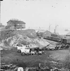
Interesting city point photo

While investigating maritime actives at City Point, I discovered an image of an apparent blockade runner at City Point. Here is crop of that image.

USS Banshee

USS Banshee

I think it is the USS Banshee, which was a captured blockade runner put to use by the US navy.

City Point web pages reorganized

Note that since the proposed City Point layout involves a busy maritime port, I’ve been investigating Maritime activities. Though I’ve been reading about the Civil War for many years, I just discovered how little I knew about the war on the water. My revised City Point web pages now include the beginnings of a “maritime” page.

Let me know what you think.

Craftsman Structure Convention in Mansfield, MA

Spent some time Friday Evening building a Alkem Scale Models water tank and Saturday where I learned about backdrop painting, visited the vendors and heard Bernie Kempinski give his Civil War talk. I enjoyed meeting and talking with Bernie and the other modelers present. Building the Alkem water tank was a lot of fun. I learned quite a bit from everyone.

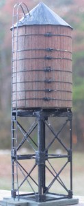
Yesterday I painted and completed assembly of the water tank and I think it turned out great. This is probably the best looking structure I’ve ever built.

Water Tank

Water Tank

This will certainly help to inspire me to get moving on the City Point model. The first part of the City Point layout I’m planning to do will be the lead in tracks. This area is probably the most basic and will allow me to experiment without having to redo a lot of structures and details. I ordered several flat cars from Bernie, as several images show flats cars parked there.

Going to this convention might be the trigger that gets me off my butt and going on the City Point model.I have torn a Mantua General all apart for a planned rebuild, I just need to figure out how to mill down the flanges on those drivers.

Civil War Olive Green

Based on some new photoshop experiments, I’m starting to think I was off on my Civil War Carriage Olive Green assessment. Check out my updated page.

http://www.willegal.net/iron_brigade/olivepaint.htm

Also note that I discovered a new City Point Photo on the National Archives pages.

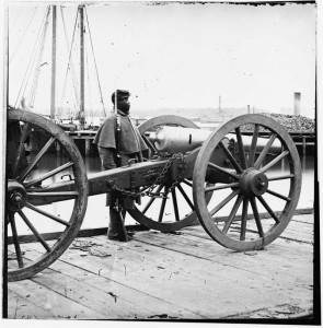
Napoleon on the ordnance wharf at City Point

Napoleon on the ordnance wharf at City Point

This is listed as at unknown location, but it clearly is taken on the ordnance wharf at City Point. You can even see lettering on the carriage that indicates that it came from Washington Arsenel to City Point. The Library of Congress call number is: LC-B811-2582

A while back I found a photo at the National Archives that was identified as taken at City Point, but was actually taken at Belle Plain. I send an email to the administrators and they said they didn’t have time to verify my assertion and make a change. This item can be found on the National Archives website by searching for ARC identifier 529319.

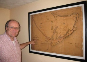
City Point Map Framed

City Point Map Framed

City Point Map Framed

It took a while, but I have framed my original sized city point map.  Since I didn’t want to crop out the edges with the frame, I did this a little differently than other pictures that I’ve framed. I cut a piece of 1/8″ particle board a little oversize.  The size I cut was 48.25 by 35.  I painted the board with several coats of bright white latex paint.  Then I used acid free Best-Test paper cement to glue only the top portion of the map to the board.  The bottom part of the map basically hangs from the top, which is securely glued to the board.  Over the top is a piece of plexiglas cut to the same size as the board.  I then cut and assembled the frame from hardwood.   The frame is painted a matt black.  The particle board is heavy, but I couldn’t find another material that would be large enough to support this large map.  Total cost was $35 for the map, $39 for the plexiglas and $14 for the wood for the frame.  I already had the particle board and the paint, so that didn’t cost me anything.

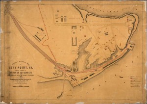
Full Scale City Point Map

I had zazzle.com print a full scale (45.3″x32″) copy of Merrick’s City Point map on matt UV paper.  The regular $52 price was cut in half by a 50% off sale and shipping was only $6.99.   The result is awesome and i can’t wait to frame it and find a place to display it.  This is going to motivate me to move forward on a railroad.

City Point Map, 1865